Cleanup process begins for storm victims (with video)
Published 9:48 am Monday, April 3, 2017

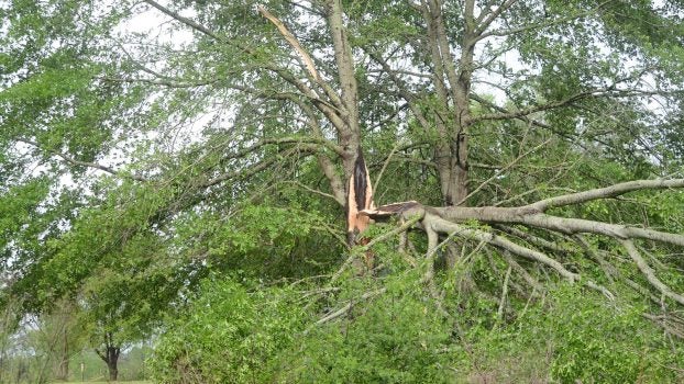
Dunn-Ratcliff Road

Dunn-Ratcliff Road

Dunn-Ratcliff Road

Off Dunn-Ratcliff Road

Dunn-Ratcliff Road

Off Dunn-Ratcliff Road

Dunn-Ratcliff Road

Dunn-Ratcliff Road

Dunn-Ratcliff Road

Dunn-Ratcliff Road

Dunn-Ratcliff Road

Old Red Star Drive

Old Red Star Drive

Old Red Star Drive

Old Red Star Drive

Old Red Star Drive

Dunn-Ratcliff Road

Near Quality Homes of Brookhaven

Dunn-Ratcliff Road

Quality Homes of Brookhaven
Lincoln Countians were out assessing the damage and starting the cleanup process Monday morning after severe storms downed dozens of trees and damaged property.
Homes, sheds and carports along Dunn-Ratcliff Road and Old Red Star Drive were damaged by fallen trees. The storm hit at about 1:30 a.m. It was unclear if the damage was from a tornado or straight-line winds. Typically, the National Weather Service office in Jackson will conduct a storm survey to determine what caused the damage.
Power lines and power poles were damaged by the storm. About 1,150 Southwest Electric customers were without power at 2 p.m. Monday.
Central Electric based in Carthage is sending two crews and their trucks to help Southwest’s crews.
More than 1,000 Entergy customers were also without power. Magnolia Electric Power reported 450 customers without power earlier today.
All but two of those has been restored.
Southwest said 33 linemen, servicemen and right-of-way crew members worked through the night and into today on Hwy. 550, Zetus Road, Dunn-Ratcliff Road, Old Red Star Drive and Jackson Liberty Road.
Crews are still assessing the damage, but Southwest has determined that at least seven poles are broken, five of which hold three-phase lines, on Dunn-Ratcliff and Old Red Star. In addition, several cross-arms in the area are stripped and will have to be replaced.
It is estimated that the power to the affected area will be back by Tuesday. “Replacing poles and cross-arms is a labor-intensive process and takes time. We appreciate our Members’ patience during this time,” said David Strittman, line superintendent.
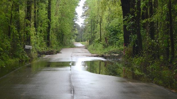
Seven homes were damaged, according to officials. Thirty-five roads were blocked by trees and powerlines at one point Monday morning. Several roads in the county were also underwater.
Residents on Windwood Terrace were busy sawing limbs and cleaning up.
“Last night I thought it was straight-line winds but as daylight came and I saw the tops blown out of the trees I thought it was a tornado. The damage is circular. There’s no one direction it came from,” Jerry Hoeniges said as he raked limbs.
His home had shingle damage but no trees on it. He was out with his son cleaning up in his neighbors’ yards.
“Today’s a cleanup day. A day to reflect on the blessings of God,” he said about being thankful the damage wasn’t worse.
On Dunn-Ratcliff Road, residents were out with tractors helping neighbors clear fallen trees and limbs.
Garrett Dunn’s carport was damaged but his house was spared.
“I’m alive,” he said over the sound of a nearby tractor.
His work truck parked at a shed behind the house was damaged when the shed collapsed on it.
“It scared the fire out of me. It was loud, real loud,” Dunn said. “If it was a tornado, I’m going to say we were on the edge of it.”
Most of the hardwoods on his property were snapped or blown down. At a property down the road, pieces of tin from a barn were scattered in a pasture.
Trees were also blown down along Hwy. 51 north of Brookhaven and on Jackson Street in Brookhaven.
Debris from a nearby billboard damaged homes at Quality Homes of Brookhaven on Jakes Trail. Several trees were blown down along that road.
The National Weather Service in Jackson has issued a flood warning for the Pearl River near Monticello affecting Lawrence County.
Flooding of the Pearl River is also expected near Rockport affecting Copiah and Simpson counties and near Columbia affecting Marion County.
Do not drive or walk through areas where water covers the roadway. The water may be deeper than it appears.
At 11:15 a.m. Monday the stage was 18.5 feet with moderate flooding forecast. Flood stage is 22 feet.
The river will rise above flood stage by tonight and will continue to rise to near 26 feet by early Saturday morning.
This crest compares to a previous crest of 27.8 feet on Mar 20 2016.
At 26 feet water covers Old Highway 27 about seven miles north of Monticello near St. James Missionary Baptist Church.
At 25 feet water begins to flood lower portions of Cooper`s Ferry Park in Monticello.
At 24 feet water appears in low areas in the extreme eastern portion of the city of Monticello.
At 22 feet water inundates some lowland and agricultural land near the river.
More Galleries


-
Polls
 Loading ...
-
-