Severe weather likely Wednesday
Published 5:05 pm Tuesday, March 16, 2021
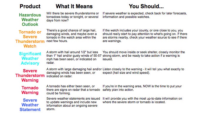
- National Weather Service image
Severe weather is likely for Wednesday afternoon and evening across the area, according to the latest reports from the National Weather Service and the National Oceanographic and Atmospheric Administration.
Some strong, long-tracked tornadoes are likely, NWS predicts, along with hail up to golfball size and damaging winds that may exceed hurricane force of 75 mph.
Scattered thunderstorms are expected to move into the Lincoln County area around 8 a.m. and last until noon, when stronger storms are forecast until after 11 p.m.
According to NWS, the worst of the weather is expected to hit the area in the time period of 6-10 p.m., moving from the west.
Clifford Galey, the county’s Emergency Management Director, advises residents to be prepared and keep an eye on the weather conditions.
Weather.gov suggests checking flashlights and radios for fresh batteries, having cell phones fully charged and preparing a severe weather safety kit, if one is not already handy. Keep shoes on or nearby, along with personal ID and car keys.
When a tornado or severe thunderstorm watch is issued, it means conditions are favorable for such to develop. When a warning is issued, that means the potentially dangerous weather is headed in your direction.
When a severe thunderstorm warning is issued, move indoors away from windows, and monitor weather information closely.
When a tornado warning is issued, move quickly, get to shelter in the innermost room of the building or lowest floor. Get underground if possible. Number one killers from storms are flying and falling debris. Use pillows, coats, helmets, etc. to protect your head and body.
When a warning is issued, do not open windows or doors, do not seek shelter under a highway overpass and do not go outside looking for the tornado. None of these ideas is safe, according to NWS.
More News


-
Polls
 Loading ...
-
-