Storms could threaten Friday afternoon commute
Published 11:08 am Friday, April 21, 2023
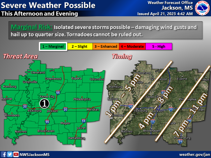
BROOKHAVEN — Severe thunderstorms threaten Southwest Mississippi this afternoon and into the evening as a precursor to a nearing cold front. Winds, hail and tornadoes are all concerns for the area.
National Weather Service in Jackson forecasts damaging wind gusts could reach 60 mph which could cause trees to fall over, branches to break off and high profile vehicles to become unsteady. Hail could be as big as quarter size, meaning the hail is one inch in diameter.
Isolated severe thunderstorms could move through the area between 4 p.m. and 8 p.m. tonight. Tornadoes are possible and can not be ruled out according to the NWS in Jackson. Mississippi has seen 31 tornadoes since Jan. 1, 2023 and one of those touched down in the Little Bahalia Community in Lincoln County.
Heavy rainfall is another danger for the area. Rainfall of two to three inches could be possible in a few hours of time which could lead to flash flooding. Low lying areas and urban settings are most at risk of flash flooding. Small rivers, creeks, bayous and ponds might become inundated with water too.
Showers are still likely tonight with a 70 percent chance of rain. Fortunately, Saturday and Sunday are forecast to be nice and sunny with highs in the low 70s and lows in the 50s.
Check back for updates before, during and after severe weather threatens our area. If severe storms do hit we will give updates on power outages and emergency services.
After a storm, we provide information on how you can help those in need. Brookhaven’s response to the tornadoes which tore through Amory and Rolling Fork last month was incredible.
Please send any pictures or videos of storm damage, strong winds, hail, tornadoes, intense lighting or other weather oddities to hunter.cloud@dailyleader.com. Stay weather aware and safe.
More News - Main


-
Polls
 Loading ...
-
-