Damage Thursday possibly from tornado; Severe storms expected through Saturday
Published 10:23 am Friday, January 20, 2017

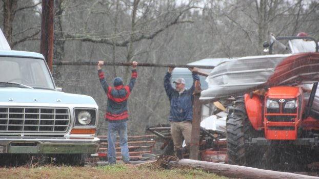
Photo by Orionna Brumfield/Jimmy Anderson Jr. helps remove debris from the damage done to Jimmy Anderson Sr.’s barn and tractor following Thursday’s severe weather.


A truck travels on a flooded street Thursday morning.
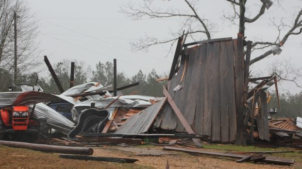
Survey teams with the National Weather Service canvassed areas damaged by severe storms Thursday, confirming an EF-2 east of Magee and checking into the possibility of a tornado near Wesson.
More survey teams would be out today in the areas reporting damage, including Copiah County where a barn on Anderson Road in Wesson was destroyed, said NWS meterologist Thomas Winesett.
He said it’s not known yet if it was straight line winds or a tornado.
“It’s a potential tornado but nothing’s been confirmed,” he said.
The storm ripped apart Jimmy Anderson Sr.’s barn, leaving his tractor buried under a pile of mangled sheet metal and boards.
His son and some neighbors helped him start the cleaning process at his farm on Anderson Road.
“We think it was a tornado, but we’re just trying to get our tractor and equipment out,” Jimmy Anderson Jr. said. “Everyone is safe so that’s all that matters.”
Several roads flooded in Lincoln County as rains continued through early afternoon.
Franklin County residents near the McCall Creek area Thursday afternoon were given a reprieve as authorities opened up a beaver dam to lower the level of the water pushing against Gayle Evan Lake Dam, Winesett said.
If the dam fails, five to seven feet of water is possible near the dam and four to five feet of water could flood Hwy. 84 nearby.
“They let the water out and the stress out,” he said. “It will be something to keep an eye on for Friday afternoon,” he said Thursday.
A secondary dam had a failure Thursday morning which caused some flooding to Hwy. 84.
Winesett said there is a heavy rain potential in southwest Mississippi today.
“Expect two rounds of severe storms,” he said.
The first round will come late Friday night to early Saturday morning, possibly before daybreak. Lincoln County and the surrounding area could see large hail, damaging winds and “a few tornadoes as well,” he said.
There will be a lull early Saturday afternoon, followed by the possibility of more damaging hail and wind and “an isolated tornado or two.”
The NWS said there is a little more uncertainty with the second round and the main threat will be for the large hail.
More Galleries


SportsPlus
How to Watch the Braves vs. Phillies Game: Streaming & TV Channel Info for August 31
Marcell Ozuna and the Atlanta Braves hit the field on Saturday at Citizens Bank Park against Zack Wheeler,…
Braves vs. Phillies: Betting Preview for August 31
Atlanta Braves (74-61) will match up with the Philadelphia Phillies (79-56) at Citizens Bank Park on Saturday, August…
How to Watch MLB Baseball on Saturday, August 31: TV Channel, Live Streaming, Start Times
The Los Angeles Dodgers versus the Arizona Diamondbacks is one of many compelling options on today’s MLB schedule.…
How to Watch the WNBA Today | August 31
The Connecticut Sun versus the Washington Mystics is your one and only option on today’s WNBA slate. The…
WNBA Betting Picks: Saturday, August 31
Wondering how you should bet on today’s WNBA game? Look no further. Below you’ll find computer predictions on…
-
Polls
 Loading ...
-
-