Weather could last until early Wednesday morning
Published 10:59 am Tuesday, November 29, 2022
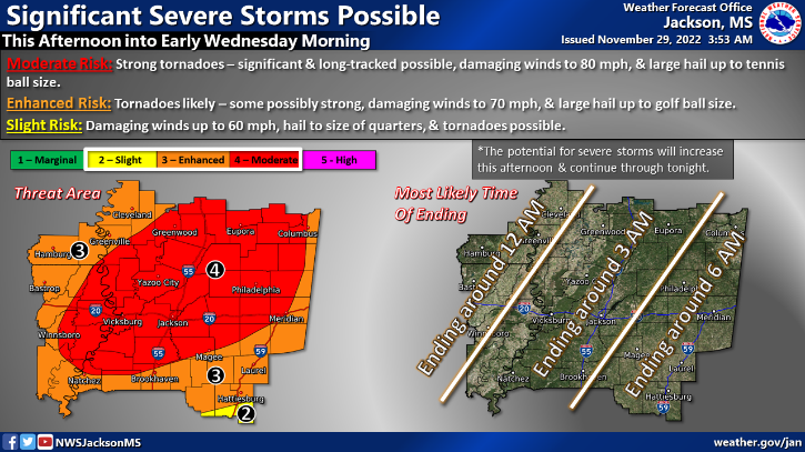
BROOKHAVEN — Severe weather is forecast to hit much of Mississippi Tuesday afternoon according to the National Weather Service in Jackson. The forecast calls for rain, strong winds and potential for tornadoes.
The majority of Lincoln, Franklin and Adams Counties are in the enhanced risk zone meaning tornadoes are likely, winds could reach 70mph and there could be golf-ball sized hail. However, norther sections of the counties fall in the moderate risk zone meaning they could strong tornadoes, tennis to golf ball sized hail and strong winds up to 80mph.
NWS Jackson forecasts the storms to hit Southwest Mississippi from this afternoon until 3 a.m. Wednesday morning and asks residents to stay weather aware. Flash flooding is also a concern with localized heavy rain fall inundating low lying areas, urban areas and creeks, bayous or rivers.
There is a 100 percent chance of severe thunderstorms this evening.
See any crazy hail, wicked storm damage or blistering winds? Please share pictures and videos to news@dailyleader.com with information about where you captured the images.
More News


SportsPlus
How to Watch the Braves vs. Phillies Game: Streaming & TV Channel Info for August 31
Marcell Ozuna and the Atlanta Braves hit the field on Saturday at Citizens Bank Park against Zack Wheeler,…
Braves vs. Phillies: Betting Preview for August 31
Atlanta Braves (74-61) will match up with the Philadelphia Phillies (79-56) at Citizens Bank Park on Saturday, August…
How to Watch MLB Baseball on Saturday, August 31: TV Channel, Live Streaming, Start Times
The Los Angeles Dodgers versus the Arizona Diamondbacks is one of many compelling options on today’s MLB schedule.…
How to Watch the WNBA Today | August 31
The Connecticut Sun versus the Washington Mystics is your one and only option on today’s WNBA slate. The…
WNBA Betting Picks: Saturday, August 31
Wondering how you should bet on today’s WNBA game? Look no further. Below you’ll find computer predictions on…
-
Polls
 Loading ...
-
-