Severe storm threat looms over area
Published 11:33 am Friday, March 24, 2023
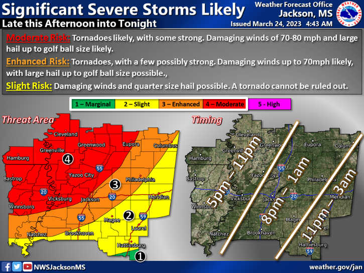
BROOKHAVEN — Severe storms are expected to hit Lincoln County and the surrounding area Friday night from 8 p.m. to 1 a.m. Saturday. Winds will pick up to 15 mph this afternoon and there is a 30 percent chance of rain today.
A portion of Northwest and North Lincoln County is at moderate risk of severe storms Friday night while the rest of the county and Lawerence County are under a slight risk.
NWS Jackson forecasts this storm to produce damaging winds reaching 70 to 80 mph. In enhanced risk areas, tornadoes are a risk and some might be strong. There could be golf ball sized hail.
In slight risk areas, quarter size hail, damaging wind gusts and tornadoes can not be ruled out.
This storm will hit the area at night when most people are sleeping so make sure you have ways to get alerts in case a tornado warning or watch is issued.
“Take the time today to plan a sturdy home or community shelter to stay in if a Watch is issued for your location,” NWS Jackson states. “The threat for severe weather will decrease as storms progress farther south and east tonight, but severe storms with damaging wind gusts, hail, and possible tornadoes may develop even in southeastern parts of our forecast area late tonight.”
A potential severe storm could hit the area Sunday afternoon as well. Hail and damaging winds are the concern for that day as well but no further information including a time window has been released by the NWS.
Check back for more updates as the storm gets closer and hits the area.
Please email hunter.cloud@dailyleader.com to report any storm damage or to submit photos or pictures from tonight’s weather events.
More News


SportsPlus
How to Watch MLB Baseball on Friday, July 26: TV Channel, Live Streaming, Start Times
The Cleveland Guardians and the Philadelphia Phillies hit the field in one of many exciting matchups on the…
How to Watch the Braves vs. Mets Game: Streaming & TV Channel Info for July 26
Charlie Morton will start for the Atlanta Braves in the second of a four-game series against the New…
Braves vs. Mets: Betting Preview for July 26
Francisco Lindor will lead the way for the New York Mets (54-48) on Friday, July 26, when they…
New Orleans Saints vs. Las Vegas Raiders Week 17 Tickets Available – Sunday, December 29 at Caesars Superdome
On Sunday, December 29, 2024, the Las Vegas Raiders (0-0) challenge the New Orleans Saints (0-0) at Caesars…
New Orleans Saints vs. Atlanta Falcons Week 10 Tickets Available – Sunday, November 10 at Caesars Superdome
A couple of NFC South rivals clash on Sunday, November 10, 2024 at Caesars Superdome when the New…
-
Polls
 Loading ...
-
-