Lincoln County placed under flood watch Wednesday
Published 2:00 pm Tuesday, April 9, 2024
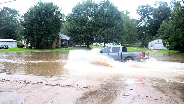
- Heavy rain fall can cause the intersection of West Congress Street and Schwem Avenue to flood. Be careful as the NWS Jackson forecasts the threat of flash flooding for SW Mississippi to continue. (Hunter Cloud | The Daily Leader)
BROOKHAVEN — National Weather Service in Jackson issued a flood watch for Lincoln County starting Wednesday morning through Wednesday evening. Areas along the Pearl River in Lawrence County are under a flood warning starting Thursday according to the National Weather Service.
A multi-day rain event could dump anywhere between 4 to eight inches of rain on Lincoln County. The Bogue Chitto River and Bayou Pierre are two local bodies of water which could experience flooding. Excessive runoff following the heavy rainfall could cause flooding of rivers, creeks, streams and low lying areas. Extensive street flooding is possible according to NWS Jackson.
“You should monitor later forecasts and be prepared to take action should Flash Flood Warnings be issued,” NWS Jackson states.
Minor flooding is forecast for the Pearl River near Monticello. At 24 feet, water starts to appear in low areas in the eastern parts of Monticello. The river stage Tuesday is at 10.5 feet. NWS Jackson forecasts the river will fall to 8.9 feet Wednesday before sharply rising Thursday morning by 10 feet. The Pearl River near Monticello is expected to rise above flood stage at 22 feet by Thursday evening and continuing to 24.5 feet Friday.
Lincoln County is placed under an elevated threat of flooding according to the National Weather Service. Forecasts show 2 to 5 inches of rain is possible with areas of flash flooding likely for the area. Some roads may become flooded and closed with some structures possibly threatened with inundation. Minor to moderate river flooding is possible for the area starting Tuesday into Wednesday evening.
The biggest weather threat for the region will not come until Wednesday. NWS Jackson placed Lincoln, Jefferson, Franklin, Copiah, Pike and Lawrence Counties under a moderate risk of severe storms. Damaging wind gusts could reach 80 mph with large hail up to golf ball size, tornadoes are likely with some possibly strong. Storms should move through the area between 11 a.m. to 4 p.m. Wednesday.
More News


SportsPlus
How to Watch the Braves vs. Phillies Game: Streaming & TV Channel Info for August 31
Marcell Ozuna and the Atlanta Braves hit the field on Saturday at Citizens Bank Park against Zack Wheeler,…
Braves vs. Phillies: Betting Preview for August 31
Atlanta Braves (74-61) will match up with the Philadelphia Phillies (79-56) at Citizens Bank Park on Saturday, August…
How to Watch MLB Baseball on Saturday, August 31: TV Channel, Live Streaming, Start Times
The Los Angeles Dodgers versus the Arizona Diamondbacks is one of many compelling options on today’s MLB schedule.…
How to Watch the WNBA Today | August 31
The Connecticut Sun versus the Washington Mystics is your one and only option on today’s WNBA slate. The…
WNBA Betting Picks: Saturday, August 31
Wondering how you should bet on today’s WNBA game? Look no further. Below you’ll find computer predictions on…
-
Polls
 Loading ...
-
-