Severe weather, tornadoes possible today
Published 9:16 am Wednesday, June 14, 2023
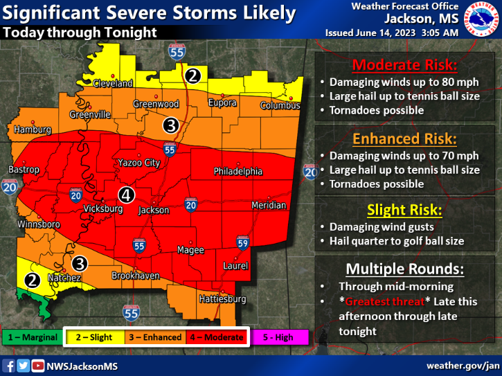

The National Weather Service in Jackson has forecasted severe storms across the state today, with enhanced to moderate risk in Lincoln County and the surrounding areas.
Enhanced risk areas can expect damaging winds up to 70 mph, large hail up to tennis ball size and possible tornadoes.
Moderate risk areas can expect damaging winds up to 80 mph in addition to the large hail and possibility of tornadoes.
The rough weather is expected in the morning, but the greatest threat exists from the late afternoon to late tonight.
The Mississippi Emergency Management Agency cautions residents to be weather aware; know where to go in case of a tornado warning; prepare for power outages; and watch for debris in the roads.
Watch vs. warning
The NWS issues a “watch” when conditions are favorable for the development of severe thunderstorms, tornado, or flash flooding. This is the time to prepare, if preparation has not already been done. Charge phones, make sure emergency kits are available and that plans are in place for family and pets if a warning is issued.
A “warning” is issued when the threat is imminent — severe weather has been reported by spotters or indicated by radar; a tornado has been sighted or indicated by weather radar; or flash flooding has been observed. This is the time to take immediate action — take shelter and listen to weather radio, if possible.
More News


SportsPlus
How to Watch the Braves vs. Phillies Game: Streaming & TV Channel Info for August 31
Marcell Ozuna and the Atlanta Braves hit the field on Saturday at Citizens Bank Park against Zack Wheeler,…
Braves vs. Phillies: Betting Preview for August 31
Atlanta Braves (74-61) will match up with the Philadelphia Phillies (79-56) at Citizens Bank Park on Saturday, August…
How to Watch MLB Baseball on Saturday, August 31: TV Channel, Live Streaming, Start Times
The Los Angeles Dodgers versus the Arizona Diamondbacks is one of many compelling options on today’s MLB schedule.…
How to Watch the WNBA Today | August 31
The Connecticut Sun versus the Washington Mystics is your one and only option on today’s WNBA slate. The…
WNBA Betting Picks: Saturday, August 31
Wondering how you should bet on today’s WNBA game? Look no further. Below you’ll find computer predictions on…
-
Polls
 Loading ...
-
-